As Britian leaves Europe, Ana and I will leave Britain. We
are very grateful for having had the chance to live here and to contribute our bit to
society. We love Scotland and Scottish adventures and we know that it is not always easy. As everyone else we often struggled
through the short, stormy and rainy days of winter interrupted only by great adventures in the
snowy hills. As our leaving do we decided to do a Scottish Highland road trip. For this Ana prepared maps for sea kayak trips and I printed maps for hillwalks in
case the weather was too bad for sea kayaking. In the end we sea kayaked every
day for five days. Scotland has again been good to us.
Day 1. Kinloch Hourn.
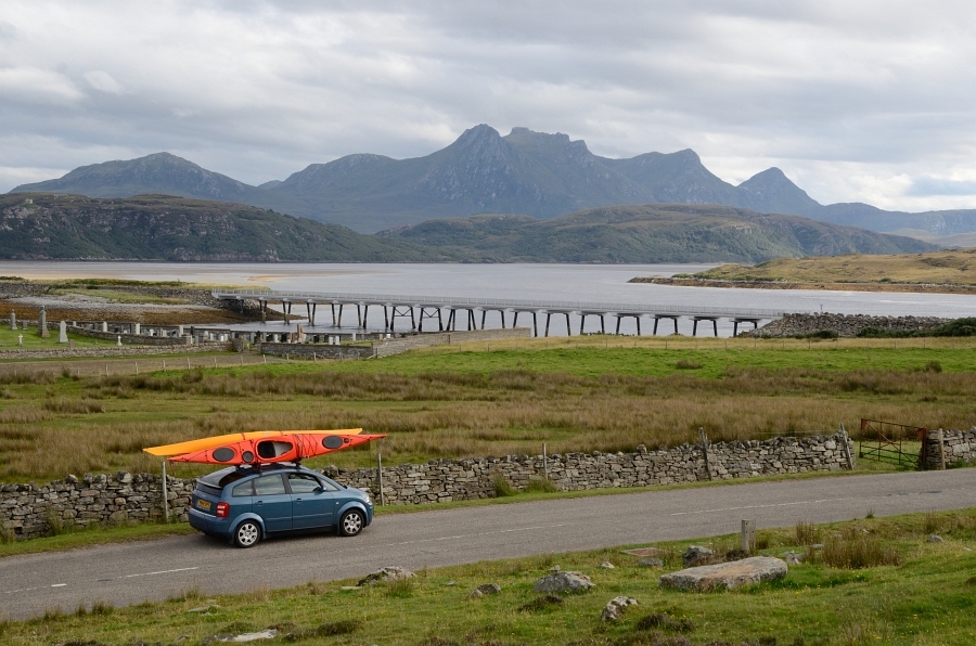
We left Tuesday evening but stayed the night in a hotel at Drumnadochit on the shores of Loch Ness. In the morning we then drove the long road down to Kinloch Hourn. When we descended the narrow single track to Kinloch Horn a Vauxhall drove past an overtaking spot and aggressively signalled to us to reverse up the hill to an overtaking spot quite a way back. Eventually the driver relented (reversing up the steep hill would have been tricky) and rolled a few metres back to his overtaking spot and let us past with a grim face. When we removed our kayaks he approached us and told us with the voice of a London bouncer to "a) learn to reverse" and b) "put a pound into the honesty box". Apparently this is Tony and he gets cracking reviews for his B&B online, presumably from Fawlty Towers fans.
We left Tuesday evening but stayed the night in a hotel at Drumnadochit on the shores of Loch Ness. In the morning we then drove the long road down to Kinloch Hourn. When we descended the narrow single track to Kinloch Horn a Vauxhall drove past an overtaking spot and aggressively signalled to us to reverse up the hill to an overtaking spot quite a way back. Eventually the driver relented (reversing up the steep hill would have been tricky) and rolled a few metres back to his overtaking spot and let us past with a grim face. When we removed our kayaks he approached us and told us with the voice of a London bouncer to "a) learn to reverse" and b) "put a pound into the honesty box". Apparently this is Tony and he gets cracking reviews for his B&B online, presumably from Fawlty Towers fans.

Near the parking space there is a little stream that leads into the loch. Here is Ana paddling the tidal stream...

We then followed the loch parallel to the footpath that goes to Barrisdale bothy, a place that Munro baggers will know as it is a key bothy in the wild bounds of Knoydart. The key hill here is Ladhar Bheinn (1020 m, https://www.walkhighlands.co.uk/munros/ladhar-bheinn). You can see a ridge leading to the summit from Ana.

Here I am a little bit later.

We went further and had lunch near Arnisdale near Beinn Sgritheall (1095 m, https://www.walkhighlands.co.uk/kintail/Beinnsgritheall.shtml). Here is Ana returning...

... and pulling the paddle up the stream to our car. Luckily Tony was busy and we got on well with all the other road users on the long single track road, stopping for them or them stopping for us, depending on was most sensible. And of course, we love the Highland single lane handwave and smile (we had hundreds of these during our trip).

Day 2. Summer isles.
From Kinloch Hourn we had to return to almost to Inverness to then drive past the Altguish Inn to Ullapool and to the campsite at Altandhu (http://www.portabhaigh.co.uk/). This campsite is perfect for kayaking the summer isles. We arrived after 23 h and woke up to a sunny morning, a chance to dry our gear.

Here a photo that we took after the paddle which shows the summer isles. A sea kayakers dream.

Here a close up showing some of the isles. The campsite is near the beach on the left above the houses in the foreground.

I had a little rest before launching.

Unfortunately the sun did not last and when we launched it was overcast.

The clouds became darker, it started to rain but there was little wind so it did not matter much. We paddled around Isle Ristol via Glas-leac Mor to Tanera Beg.

Here is Ana arriving in one of the bays of Tanera Beg...

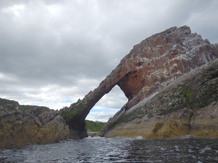
... and here is the Arch on Tanera Beg take 1...

... and take 2.

I also fished a bit and caught a decent pollack. However, I hoped for cod so I carefully released the pollack.

In the afternoon we went to Tanera Mor and then back towards the campsite at Altandhu.

We needed to carry our kayaks a short time after the jetty as it was low tide...

... but soon approached the beach with the campsite behind.

A great paddle but we did not see much of the wildlife thatlives in these waters. So kayaks back up onto the roof of Ana's A2 and back onto the road...

... past peaks such as Stac Pollaidh...

... to reach the campsite in Scourie. A few midgies and a decent sunset.

Day 3. Handa island.
We woke up to a sunny sky. The forecast was good for the morning but bad for the afternoon including the possibility of thunderstorms. However, the wind speeds would remain low and as we could cop out in Tarbert and as the distances were short we decided that the risk was acceptable. Here is the launch beach...

... and here is Ana ready to go.

A beautiful morning and a short crossing from the mainland to the isle of Handa, a nature reserve.

Here is Ana crossing the channel between Handa and the mainland.

When we left the mainland I caught another pollack which I released carefully as I was after a cod.

We arrived on a sandy beach on Handa which was our lunch spot.

Scotland at its best.

To the west Handa is flanked by steep sea cliffs. Here is Ana crossing the South-Western point of Handa...

... and here she paddles past the sea cliffs.

Here is a giant arch that was giving a rest from the swell of the Northern Atlantic.

Here more cliffs on the North Eastern point of Handa...

... and here Ana paddles between a big sea stack and the island cliffs.

Here, I pass the sea stack...

... and here is Ana in the sun to the North of the island...

... and here you can see the mainland near Tarbert in the distance.

In this photo I cross over to Tarbert where we had lunch.

In Tarbert it started to rain and the midgies were out but the weather looked stable enough to justify paddling down the sound of Handa to Scourie. Here is Ana exploring a cave on the way...

... and here is a sea urchin on the side of the cave.

Just before entering the bay of Scorie the rain hit us hard. However, in a kayak the legs are dry and it was not too cold so not too bad. Ana was still smiling.

We decided to avoid a wet night in a tent so booked into Melvich hotel (https://www.melvichhotel.co.uk/). This place was done up nicely with friendly staff and it was good to have a nice meal and spend the night in a dry place.

Day 4. Rabbit islands and Eilean nan Ron.
We then returned to Talmine on the Kyle of Tongue to paddle the Rabbit islands and Eilean nan Ron. It was a grey start to the day. Here is Ana launching...

... and here Ana...

... and I cross over to the rabbit islands with Ben Loyal (754 m, m https://www.walkhighlands.co.uk/sutherland/ben-loyal.shtml) in the clouds in the distance.

We then went to the Eastern end of Tongue bay.

At the shortest distance between the mainland we crossed the channel to Eilean nan Ronto to reach a pebble beach on the island.

Here a photo of the pebbles.

The island only has one good landing spot and otherwise large cliffs again with some big arches.

This one ended in an maritime amphitheater.

The island is actually two islands which are separated by a narrow channel.

Here, I cross the channel...

... and here, Ana explores one of the caves inside the channel.

We then crossed back over to the Rabbit islands and (just about) managed to squeeze through a small arch to reach the Western side of the islands. We needed to cross the arch on top of a wave as our kayaks would have got stuck at the bottom of a wave. A little bit of risk during a trip where we otherwise avoided risk as it was only two of us.

We arrived unharmed and unstuck on the other side to paddle back to the beach.

Here is Ana arriving...

... and here is our car ready to get packed up. The sun came out...

... and we used it to dry our gear.

Here is a photo with the islands in the distance...

... and here we make our way back to Inverness via the barren moors of Sutherland. Petrol is an issue here and we had only a quarter left which was maybe or maybe not enough to reach the next petrol station. Luckily one local man from Tongue offered us some of his petrol and we could not persuade him to take half of the money that the Monarch of Kinloch Hourn presumably would have demanded from us. He was only willing to take the market rate. So people, be extremely friendly to the Sutherland folks because they are very kind and will help you if you have a problem. We will take this as a fond memory to Munich.
We drove past the Crask Inn via Lair to Beauly (the beau lieu) near Inverness, where Robbie and Katie live. Robbie has been my best climbing partner in Scotland and Katie and Robbie met during a kayak trip.
Day 5. Moray coast from Findochty.
Scotland has so many nice corners and the Moray coast is one of them. We drove past Inverness to Findochty as Ana had previously organised paddles here. Here is a photo of the harbour and a pot of flowers in the style of a 1950s-1990s postcard.
Scotland has so many nice corners and the Moray coast is one of them. We drove past Inverness to Findochty as Ana had previously organised paddles here. Here is a photo of the harbour and a pot of flowers in the style of a 1950s-1990s postcard.

Here are Ana, Robbie and Katie getting ready for the launch...

... and here is Robbie in the harbour.

This stretch of the Moray coast is great for wildlife and playing in-between rocks.

Here, we pass the Portknockie, the next village down the coast...

... and here is Ana coming out of a channel.

It was warm, there was a wee swell and we had frequent sunshine which is heaven on the water.

The trip has also two sandstone arches...
... that are great for photos...

... if the light is right.

The Moray coast is also great for spotting dolphins. We saw 3-4 times a pod of dolphins passing us. Take 1 (this pod passed below our kayaks)...

and take 2.

We carried on past Cullen bay...

... to have lunch at the bay of Findlater castle. According to Wikipedia this is the old seat of the Earls of Findlater and seafield. The castle has first been mentioned in 1246 and the vikings had it for some time.

Beautiful water-washed stone.

Here, Ana and myself towards the end of our road trip...

... and here we launch again.

Sunshine...

... and easy paddling with great visibility. We could sea the hills of Sutherland in the North-West.

We found another arch...

... and saw more dolphins...

... and then had dinner in a hotel overlooking Cullen bay. After that home via Aberdeen to Broughty Ferry, a route that I have traveled many times over the past decade.
People, do a Scottish road trip as Scotland has so much to offer especially if you are lucky with the conditions as we were.
We finish by thanking the Tayside sea kayaking club (http://tskclub.ning.com/) which have helped us to become competent in sea kayaking and which have taught us to paddle, to steer, to rescue, to plan trips and to enjoy all of that. Being out on the water with the club, our friends and Ana is what I miss most in Munich and we will come back for visits.
HW


